[Previous]
[Contents]
[Next]
 [Comments or questions]
Copyright © 1996-2001 jsd
20 The Atmosphere
-
-
-
If you don't like the weather in Ithaca, just wait
a few minutes. It'll get worse.
— apologies to Mark Twain
20.1 Circulation Around Fronts and Low Pressure Centers
Because the earth is spinning and the air is moving, there are
significant Coriolis effects.1 You'll
never understand how weather systems work unless you pay attention to
this.
We are accustomed to seeing the rotation of storm systems depicted on
the evening news, but you should remember that even a chunk of air
that appears absolutely still on the weather map is rotating, because
of the rotation of the earth as a whole. Any chunk of air that
appears to rotate on the map must be rotating faster or slower
than the underlying surface. (In particular, the air in a storm
generally rotates faster, not slower.)
Based on their everyday indoor experience, people think they
understand how air behaves:
-
They know that the stream of air from a fan moves in a
straight line, with no particular tendency to curve right or left.
- They know that once the fan is switched off, the airflow
won't last very long or travel very far before being overcome by
friction.
However, when we consider the outdoor airflow patterns that Mother
Nature creates, the story changes completely. In a chunk of air that
is many miles across, a mile thick, and a mile away from the surface,
there can be airflow patterns that last for hours or days, because
there is so much more inertia and so much less friction. During these
hours or days, the earth will rotate quite a bit, so Coriolis effects
will be very important.
Note: In this chapter, I will use the § symbol to indicate words
that are correct in the northern hemisphere but which need to be
reversed in the southern hemisphere. Readers in the northern
hemisphere can ignore the § symbol.
20.1.1 Flow Around a Low
Suppose we start out in a situation where there is no wind, and where
everything is in equilibrium. We choose the rotating Earth as our
reference frame, which is a traditional and sensible choice. In this
rotating frame we observe a centrifugal field, as well as the usual
gravitational field, but the air has long ago distributed itself so
that its pressure is in equilibrium with those fields.
Then suppose the pressure is suddenly changed, so there is a region
where the pressure is lower than the aforementioned equilibrium
pressure.
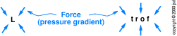
In some cases the low pressure region is roughly the same size in
every direction, in which case it is called a low pressure
center (or simply a low) and is marked with a big ``L'' on
weather maps. In other cases, the low pressure region is quite long
and skinny, in which case it is called a trough and is marked
``trof'' on the maps. See figure 20.1.
In either case, we have a pressure gradient.2 Each air parcel is subjected
to an unbalanced force due to the pressure gradient.
Initially, each air parcel moves directly inward, in the direction of
the pressure gradient, but whenever it moves it is subject to large
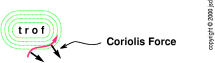
sideways Coriolis forces, as shown in figure figure 20.2.
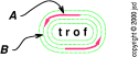
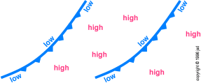
Before long, the motion is almost pure counterclockwise§ circulation
around the low, as shown in figure 20.3, and this
pattern persists throughout most of the life of the low-pressure
region. If you face downwind at locations such as the one marked A,
the pressure gradient toward the left§ is just balanced by the
Coriolis force to the right§, and the wind blows in a straight line
parallel to the trough. At locations such as the one marked B, the
pressure gradient is stronger than the Coriolis force. The net force
deflects the air.
Now we must must account for friction (in addition to
the other forces just
mentioned). The direction of the frictional force will be opposite to
the direction of motion. This will reduce the circulatory velocity.
This allows the air to gradually spiral inward.
The unsophisticated idea that air should flow from a high pressure
region toward a low pressure region is only correct in the very lowest
layers of the atmosphere, where friction is dominant. If it weren't
for friction, the low would never get filled in. At any reasonable
altitude, friction is negligible — so the air aloft just spins
around and around the low pressure region.
The astute reader may have noticed a similarity between the air in
figure 20.2 and the bean-bag in figure 19.12. In
one case, something gets pulled inwards and increases its circulatory
motion ``because'' of Coriolis force, and in the other case something
gets pulled inwards and increases its circulatory motion ``because''
of conservation of angular momentum. For a
bean-bag, you can analyze it either way, and get
the same answer. Also for a simple low-pressure center, you can
analyze it either way, and get the same answer. For a trough,
however, there is no convenient way to apply the conservation
argument.
In any case, please do not get the idea that the air spins around a low
partly because of conservation of angular momentum and partly because
of the Coriolis force. Those are just two ways of looking at the same
thing; they are not cumulative.
20.1.2 Fronts and Troughs
As mentioned above, whenever the wind is blowing in a more-or-less
straight line, there must low pressure on the left§ to balance the
Coriolis force to the right§ (assuming you are facing downwind).
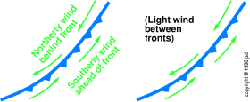
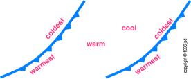
In particular, the classic cold front wind pattern (shown
in figure 20.4) is associated with a trough, (as shown in
figure 20.5). The force generated by the low pressure is the
only thing that could set up the characteristic frontal flow pattern.
The wind shift is what defines the existence of the front. Air flows one way on one side of the front,
and the other way on the other side (as shown in
figure 20.4).
Usually the front is oriented approximately north/south, and the whole
system is being carried west-to-east by the prevailing westerlies. In
this case, we have the classic cold front scenario, as shown in figure 20.4, figure 20.5, and figure 20.6.
Ahead of the front, warm moist air flows in from the south§. Behind
the front, the cold dry air flows in from the north§. Therefore the
temperature drops when the front passes. In between cold fronts,
there is typically a non-frontal gradual warming trend, with light
winds.
You can use wind patterns
to your advantage when you fly cross-country. If there is a
front or a pressure center near your route,
explore the winds aloft forecasts. Start by choosing a route that
keeps the low pressure to your left§. By adjusting your altitude
and/or route you can often find a substantial tailwind (or at least a
substantially decreased headwind).
Note: by ancient tradition, meteorologists name winds by the direction
from whence they come. A south wind (or
southerly wind) blows from south to north. Almost
everything else is named the other way. An aircraft on a southerly
heading is flying toward the south. Physicists and
mathematicians name all vectors by the direction toward which
they point. To avoid confusion, it is better to say ``wind from the
south'' rather than ``south wind''.
A warm front is in many ways the same as a cold
front. It is certainly not the opposite of a cold front. In
particular, it is also a trough, and has the same cyclonic flow
pattern.
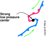
A warm front typically results when a piece of normal
cold front gets caught and spun backwards by the east-to-west
flow just north§ of a strong low pressure center, as shown
in figure 20.7. That is, near the low pressure center,
the wind circulating around the center is stronger
than the overall west-to-east drift of the whole system.
If a warm front passes a given point, a cold front
must have passed through a day or so earlier. The converse does
not hold — cold front passage does not mean you should
expect a warm front a day or so later. More commonly, the pressure
is more-or-less equally low along most of the trough. There will
be no warm front, and the cold front will be followed by fair
weather until the next cold front.
Low pressure — including cold fronts and warm fronts — is
associated with bad weather for a simple reason. The low pressure was
created by an updraft that removed some of the air, carrying it up to
the stratosphere. The air cools adiabatically as it rises.
When it cools to its dew point, clouds and precipitation result. The
latent heat of condensation makes the air warmer than its
surroundings, strengthening the updraft.
Ascending air Þ low pressure at the surface
Ascending air Þ clouds
|
|
The return flow down from the stratosphere (high pressure, very dry
descending air, and no clouds) generally occurs over a wide area, not
concentrated into any sort of front. There is no
sudden wind shift, and no sudden change in temperature. This is not
considered ``significant weather'' and is not marked on the charts at
all.
20.2 Pressure and Winds Aloft
Air shrinks when it gets cold. This simple idea has some important
consequences. It affects your altimeter, as will be discussed in
section 20.2.2. It also explains some basic facts about the
winds aloft, which we will discuss now.
20.2.1 Thermal Gradient Wind
Most non-pilots are not very aware of the winds aloft. Any pilot who
has every flown westbound in the winter is keenly aware of some basic
facts:
- The winds aloft tend to come from the west.
- They are much stronger in the winter.
- They get stronger and stronger as altitude increases.
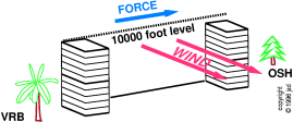
A typical situation is shown in figure 20.8. In
January, the average temperature in Vero Beach, Florida,
is about 15 Centigrade (59 Fahrenheit), while the average temperature
in Oshkosh, Wisconsin is about -10 Centigrade (14
Fahrenheit). Imagine a day where surface winds are very weak, and the
sea-level barometric pressure is the same everywhere, namely 1013
millibars (29.92 inches of mercury).
The pressure above Vero Beach will decrease with
altitude. According to the International Standard Atmosphere
(ISA), we expect the pressure to be 697 millibars at 10,000 feet.
Of course the pressure above Oshkosh will decrease
with altitude, too, but it will not exactly follow the ISA, because
the air is 25 centigrade colder than standard. Air shrinks when
it gets cold. In the figure, I have drawn a stack of ten boxes
at each site. Each box at VRB contains the same number of air
molecules as the corresponding box at OSH.3 The pile of boxes is shorter at OSH than it is at VRB.
The fact that the OSH air column has shrunk (while
the VRB air column has not) produces a big effect on the winds
aloft. As we mentioned above, the pressure at VRB is 697 millibars
at 10,000 feet. In contrast, the pressure at OSH is 672 millibars
at the same altitude — a difference of 25 millibars.
This puts a huge force on the air. This force produces a motion,
namely a wind of 28 knots out of the west. (Once again, during most
of the life of this pressure pattern, the pressure gradient toward the
left§ is just balanced by the Coriolis force to the right§,
assuming you are facing downwind.) This is the average wind at 10,000
feet, everywhere between VRB and OSH.
More generally, suppose surface pressures are reasonably uniform
(which usually the case) and temperatures are not uniform (which is
usually the case, especially in winter). If you have low temperature
on your left§ and high temperature on your right§, you will have a
tailwind aloft. The higher you go, the stronger the wind. This is
called thermal gradient wind.
The wind speed will be proportional to the temperature
gradient. Above a large airmass with uniform temperature, there
will be no thermal gradient wind. But if there is a front between
a warm airmass and a cold airmass, there will be a large temperature
change over a short distance, and this can lead to truly enormous
winds aloft.
In July, OSH warms up considerably, to about 20 centigrade,
while VRB only warms up slightly, to about 25 centigrade. This
is why the thermal gradient winds are typically much weaker in
summer than in winter — only about 5 knots on the average at
10,000 feet.
In reality, the temperature change from Florida to
Wisconsin does not occur perfectly smoothly; there may be large
regions of relatively uniform temperature separated by rather
abrupt temperature gradients — cold fronts or warm fronts. Above
the uniform regions the thermal gradient winds will be weak, while
above the fronts they will be much stronger.
For simplicity, the foregoing discussion assumed the sea-level
pressure was the same everywhere. It also assumed that the
temperature profile above any given point was determined by the
surface temperature and the ``standard atmosphere'' lapse rate. You
don't need to worry about such details; as a pilot you don't need to
calculate your own winds-aloft forecasts. The purpose here is to make
the official forecasts less surprising, less confusing, and easier to
remember.
20.2.2 High Altimeter due to Low Temperature
An aircraft altimeter does not really measure altitude.
It really measures pressure, which is related to
altitude, but it's not quite the same thing.
In order to get an estimate of the altitude, the altimeter depends on
a two-step process. First, the altimeter has a knob whereby you can
adjust things to account for how the local weather raises or lowers
the atmospheric pressure. You should make this adjustment on the
runway before takeoff, and for extended flights you should get updated
settings via radio.
Secondly, the altimeter assumes that the actual atmospheric pressure
varies with altitude the same way the the standard atmosphere would.
This is roughly 3.5% per thousand feet, more or less, depending on
temperature.
The problem is that there is no correction for nonstandard
temperature. Therefore if you set the altimeter to indicate correctly
on the runway at a cold place (such as OSH in our example), it will be
off by hundreds of feet after you climb to 10,000 feet. It will
indicate that you are higher than you really are. This could get you
into trouble if you are relying on the altimeter for terrain
clearance. (Fortunately, there are no 10,000 foot mountains near OSH.
In Alaska, though, you have to be careful because there are plenty of
mountains and plenty of cold air.) The mnemonic is HALT — High
Altimeter because of Low Temperature.
20.3 Prevailing Winds and Seasonal Winds
A parcel of air will have less density if it has
- a higher temperature,
- a higher dewpoint, and/or
- a lower pressure.
If a parcel of air is less dense than the surrounding
air, it will be subject to an upward force.4
20.3.1 Primary Circulation Patterns
We know that the tropics are hotter and more humid than the
polar regions. Therefore there tends to be permanently rising air at
the equator, and permanently sinking air at both
poles.5 This explains why equatorial regions are
known for having a great deal of cloudy, rainy weather, and why the
polar regions have remarkably clear skies.
You might think that the air would rise at the equator, travel to the
poles at high altitude, descend at the poles, and travel back to the
equator at low altitude. The actual situation is a bit more
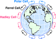
complicated, more like what is shown in figure 20.9. In each
hemisphere, there are actually three giant cells of circulation.
Roughly speaking, there is rising air at the equator, descending air
at 25 degrees latitude, rising air at 55 degrees latitude, and
descending air at the poles. This helps explain why there are great
deserts near latitude 25 degrees in several parts of the world.
The three cells are named as follows: the Hadley cell (after
the person who first surmised that such things existed, 250 years
ago), the Ferrel cell, and the polar cell. The whole
picture is called the tricellular theory. It correctly
describes some interesting features of the real-world situation, but
there are other features that it does not describe correctly, so it
shouldn't be taken overly-seriously.
You may be wondering why there are three cells in each hemisphere, as
opposed to one, or five, or some other number. The answer has to do
with the size of the earth (24,000 miles in circumference), its speed
of rotation, the thickness of the atmosphere (a few miles), the
viscosity of the air, the brightness of the sun, and so forth. I
don't know how to prove that three is the right answer — so let's
just take it as an observed fact.
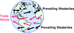
Low pressure near 55 degrees coupled with high pressure near 25
degrees creates a force pushing the air towards the north§ in the
temperate regions. The air responds to this force with motion in the
perpendicular direction, namely from west to east. As shown in figure 20.10, these are the prevailing westerlies that are
familiar to people who live in these areas.
According to the same logic, low pressure near the equator coupled
with high pressure near 25 degrees creates a force toward the equator.
The air responds to this force with motion in the perpendicular
direction, namely eastward. These are the famous trade winds,
which are typically found at low latitudes in each hemisphere, as
shown in figure 20.10.
In days of old, sailing-ship captains would use the
trade winds to travel in one direction and use the prevailing
westerlies to travel in the other direction. The regions in between,
where there was sunny weather but no prevailing wind, were named
the horse latitudes. The region near the equator where
there was cloudy weather and no prevailing wind was called the
doldrums.
The boundaries of these great circulatory cells move with the sun.
That is, they are found in more northerly positions in July and in
more southerly positions in January. In certain locales, this can
produce a tremendous seasonal shift in the prevailing wind, which is
called a monsoon.6
20.3.2 Continental / Oceanic Patterns
Now let us add a couple more facts:
-
The sun
is not very effective at heating the air,
especially dry air. Normally, the sun heats the surface of the
planet, then the air gains heat from the surface — partly by simple
contact, and partly by absorbing energy-rich water vapor that
evaporates from the surface.
- When we change from winter to summer, solar heating
warms the dry land much more quickly than the ocean.7 This is because the ocean is constantly being stirred. To
heat up the land, you need only heat up the top few inches of soil.
To heat up the ocean, you need to heat up several feet of water.
As a consequence, in temperate latitudes, we find that in summer, the
land is hotter than the ocean (other things, such as latitude,
being constant), whereas in winter the land is colder than the
ocean.
This dissimilar heating of land and water creates huge areas of low
pressure, rising air, and cyclonic flow over the oceans in
winter, along with a huge area of high pressure and descending air
over Siberia. Conversely there are huge areas of high pressure,
descending air, and anticyclonic flow over the oceans in summer.
These continental / oceanic patterns are superimposed
on the primary circulation patterns. In some parts of the world,
one or the other is dominant. In other parts of the world, there
is a day-by-day struggle between them.
Very near the surface (where friction dominates),
air flows from high pressure to low pressure, just as water flows
downhill. Meanwhile, in the other 99% of the atmosphere (where
Coriolis effects dominate) the motion tends to be perpendicular
to the applied force. The air flows clockwise§ around a high
pressure center and counterclockwise§ around a low pressure center,
cold front, or warm front.
Although trying to figure out all the details of the atmosphere from
first principles is definitely not worth the trouble, it is comforting
to know that the main features of the wind patterns make sense. They
do not arise by magic; they arise as consequences of ordinary physical
processes like thermal expansion and the Coriolis effect.
If you really want to know what the winds are doing at
10,000 feet, get the latest 700 millibar constant pressure
analysis chart and have a look. These charts used to be nearly
impossible for general-aviation pilots to obtain, but the situation is
improving. Now you can get them by computer network or fax. On a
trip of any length, this is well worth the trouble when you think of
the time and fuel you can save by finding a good tailwind.
A few rules of thumb: eastbound in the winter, fly high. Westbound in
the winter, fly lower. In the summer, it doesn't matter nearly as
much. In general, try to keep low pressure to your left§ and high
pressure to your right§.
- 1
- The origin of
the Coriolis effect is discussed in section 19.3.
- 2
- In
general, a gradient has to do with how steeply
something changes from place to place.
- 3
- The
bottom box starts at sea level at both sites. We ignore the fact
that OSH is actually 808 feet above sea level. The fact that
the ground ``sticks up'' into the bottom box doesn't change
the essence of the argument. This is consistent with the notion
that you adjust your altimeter to read 808 (not zero) on the ground
at OSH.
- 4
- It
would be simpler, but less accurate, to say ``hot air rises''.
For one thing, if all the air is hot, none of it will rise.
Secondly, it is important to keep in mind that an upward force
is not necessarily the same as upward motion.
- 5
- Although there is, as expected, somewhat low pressure at
the equator (and very low density, when you take humidity into
account), there is not any noticeable high pressure at the poles. In
fact, there is phenomenally low pressure at the south pole. I have no
idea why this is. Sorry.
- 6
- Many people take
the word ``monsoon'' to mean ``lots of rain'', but that's not the
only (or even the primary) meaning. It comes from an Arabic word
meaning ``season'', hence ``seasonal wind''. Now in parts of India
and various other places, one of the seasonal winds comes from the
ocean, bringing lots of rain.
- 7
- A
similar thing happens, on a smaller scale, when we change from night
to day.
[Previous]
[Contents]
[Next]
[Comments or questions]
Copyright © 1996-2001 jsd