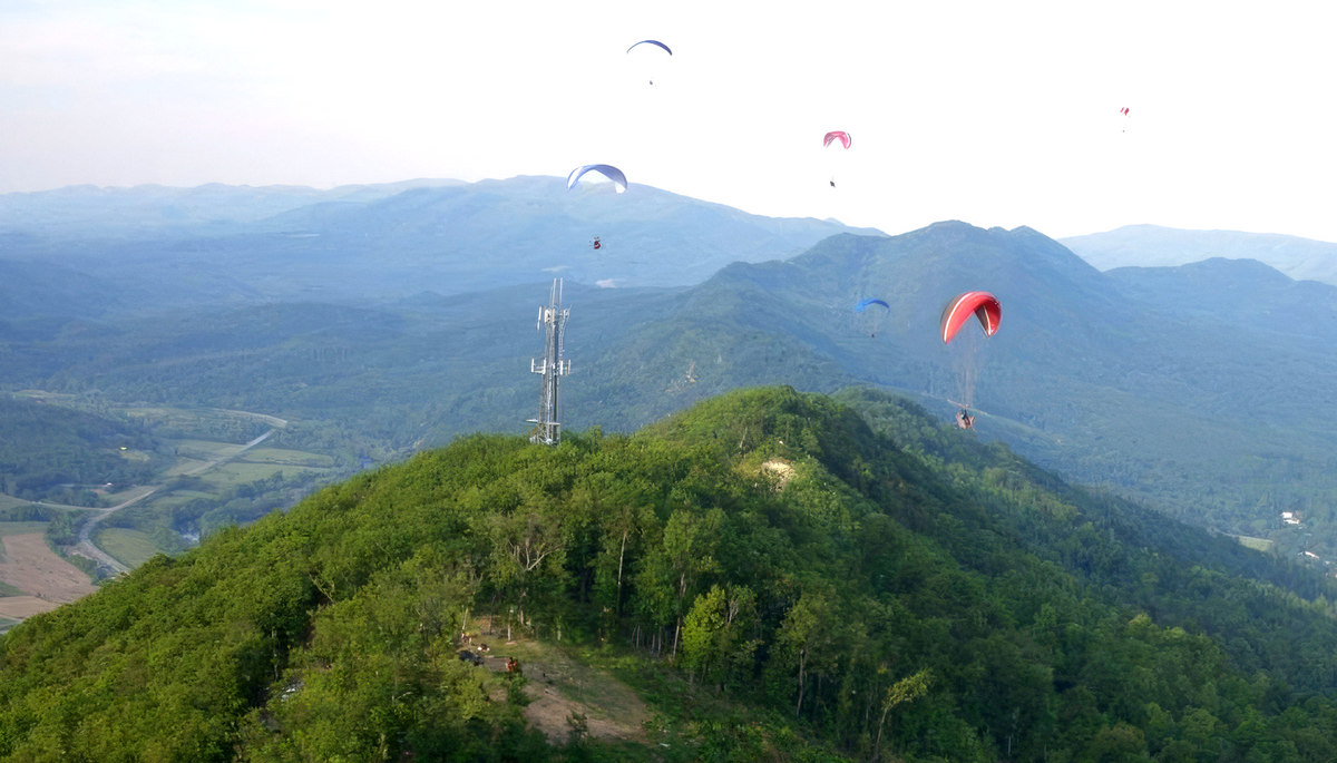
Please park across the gravel road from launch (at the base of the radio tower)
A common meeting place for both NW and SE sites is the SE Main LZ (aka "Frank's field"): 37.619216° -79.834685°
Coordinates for launches and LZ's for Eagle Rock are contained in this Site Coordinates GPX file which may be opened in Google Earth or other GPS apps.
This is an overview of the Site Locations (click to enlarge):
Launch and LZ Locations
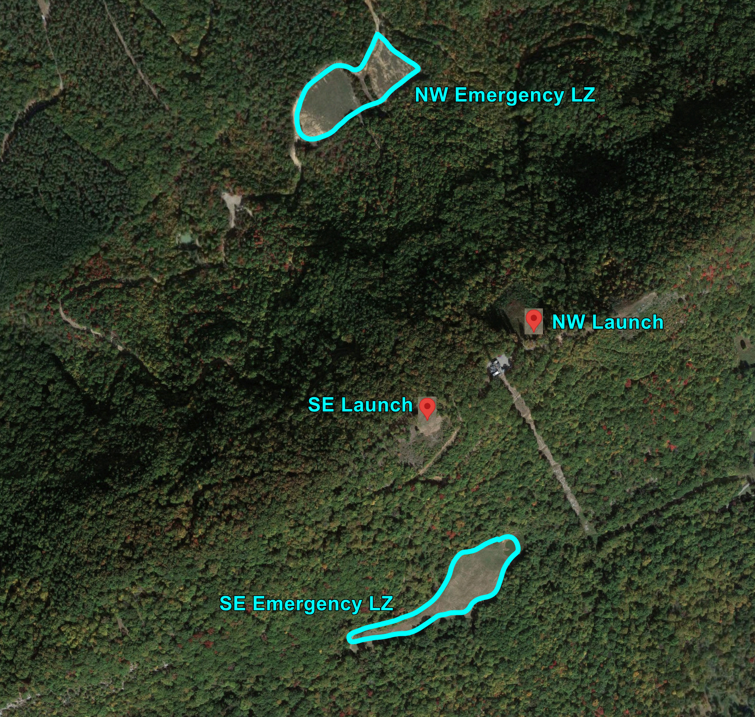
This shows a detailed view of the launches and Emergency LZs.
NOTE: These have only been used by Paragliders, and are likely too
small for use by a hang glider. (click to enlarge):
Launches and Emergency Paraglider LZs
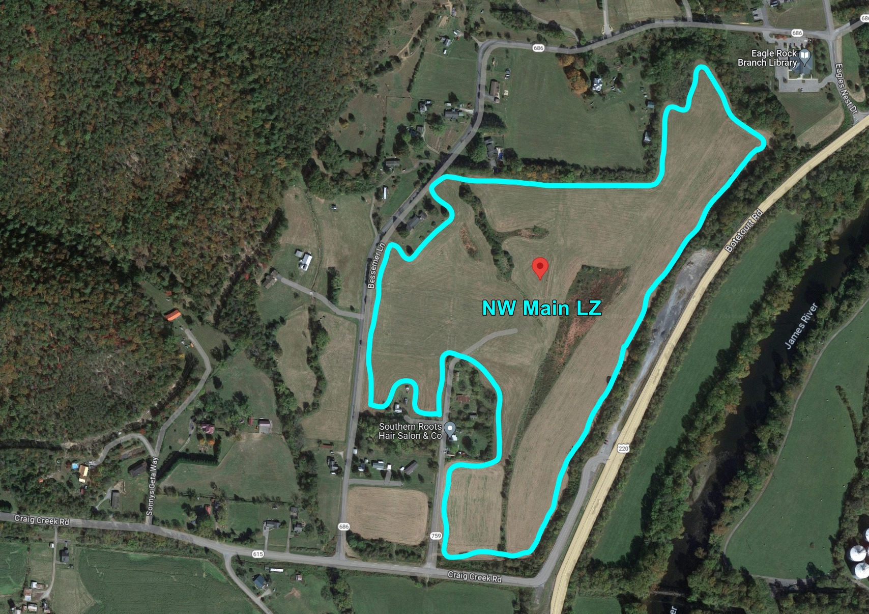
Detailed View of NW LZ. Check grass height before using. A small marshy area
may be present near the center of the LZ. (click to enlarge):
NW LZ Location
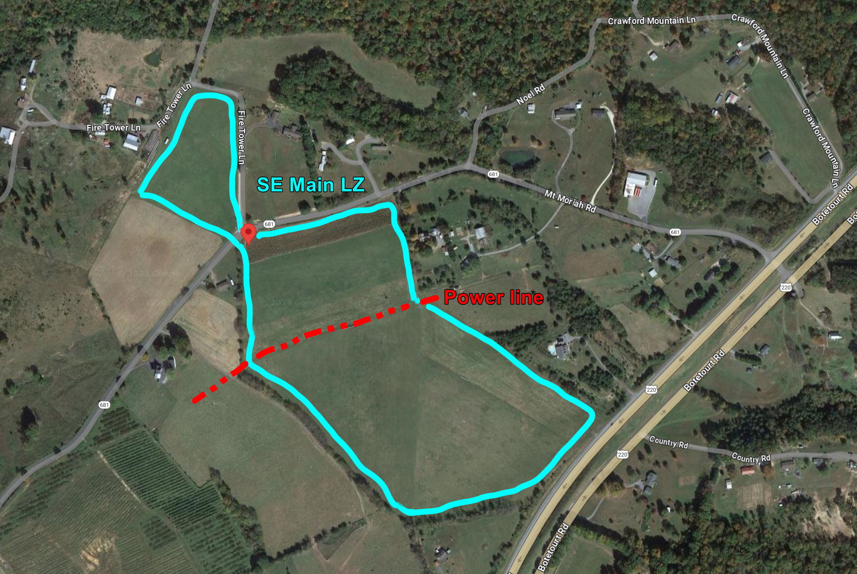
Detailed View of Primary SE LZ. Note that a powerline bisects the field (click to enlarge):
SE Primary LZ
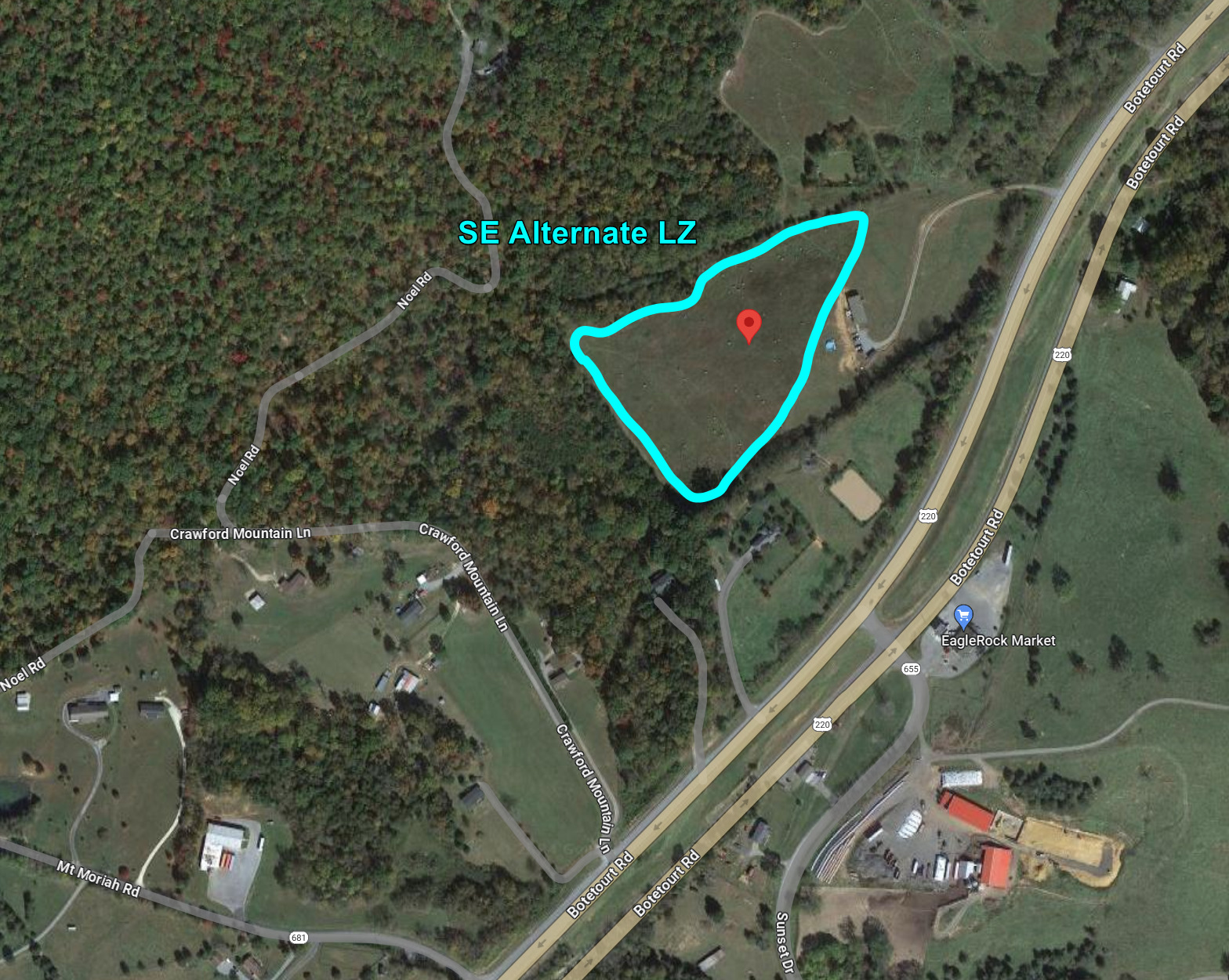
Detailed View of Alternate SE Paraglider LZ (hang gliders should use the Primary SE LZ) (click to enlarge):
SE Alternate Paraglider LZ
Launch & LZ info - use Site Coordinates GPX file for location of alternate LZ's (click on image to expand)
Detailed Site Discussion
Weather Discussion
Winds in this region in the Summer months typically average less than 10 mph, with the Westerly direction dominating. Deviation
from this pattern is usually associated with movement of weather systems. In colder winter months, wind velocity averages
increase and show a shift towards the NW, but little flying is done then. Further discussion will center on warmer periods.
There are several scenarios which are common at this Site, which will be discussed in turn.
Light winds, sunny days - this is a very common scenario. If winds are light enough (<5), local heating effects
tend to override the prevailing direction, especially on the SE side, where early day heating initiates convection effects
that can make the site flyable for much of the day, although these will often be limited to sled rides. Convection on the
NW side may often be present as well, if slightly later in the day. There have been a number of such days in which there
have been gliders flying both the SE and NW launches at the same time.
Moderate winds, splitting the ridge - this is another common scenario, and care should be taken to not to confuse
it with the case above, which can easily be done. The Crawford mountain ridge is aligned SW to NE, so winds in the range
from S to W (very common here) will end up splitting and flowing along both sides of the ridge. Depending on the prevailing
direction, this wind can seem to be "coming in" on one or both sides of the mountain. That is because both launches are
slots cut into wooded areas, and some wind has a tendency to turn and flow into these slots, thus giving the impression
that it is "coming in". Local pilot knowledge is helpful for sorting this out. Other indicators that this might be
happening are signs of stronger winds than you are seeing on launch (flags, smoke in the valley, birds soaring faster in
one direction than the other, weather station reports). If the prevailing wind is not too strong, these conditions
can generally be flown if you can find safe launch windows, but are not likely to be satisfying. There is likely to be
little lift, and the most likely outcome is a short and possibly turbulent ride to the LZ.
Frontal Passages - Warm fronts are generally preceded by S-SE winds in this area, which could provide for some soaring conditions on the SE side of the mountain, but are also frequently accompanied by rain, so they may or may not be associated
with noteworthy flying conditions. Cold fronts are another matter - these are usually followed by clearing weather and NW winds
that favor the NW side of the mountain. The main concern for these is velocity, as an energetic cold front can easily produce
winds that are unsafe to fly in. This situation is more common in Spring and Fall, and only Ravens can enjoy the favorable
wind direction. If you can find a safe flying window (perhaps a day or two after passage, but before the direction veers to
the N and NE), the unstable air can provide conditions for large altitude gains and cross-country flights. Late Spring and
early Summer cold fronts often provide a nice balance of favorable, but not excessive conditions. Cold fronts should always
be approached with caution, as they can offer some of the greatest rewards and greatest dangers.
Wonder Winds - they can and do happen at this site, either or both sides. Late afternoon and/or early evenings.
Seldom predictable, you are there for them or not. Typically we need light conditions between June and October to trigger a glass off. A large difference between the night's low and the day's high of at least 25 degrees also increases chances that this will happen.
General Site Considerations
Access Road - the road up the mountain is gravel, fairly steep, and subject to deep ruts between grading. A 4WD vehcile
is preferred for protection of both the vehicle and the road. There
are private homes along the lower section of this road, and good care should be taken to avoid raising dust.
Communications Tower - there is a Communications tower located behind the NW launch. This is only a concern for soaring
flight, as it is well above and behind both takeoff areas.
Landing Areas - both Main LZs provide ample room for landing, however they should be visited for familiarization
before flight. The terrain is not level in all areas, and a power line crosses the main SE LZ. There may also be hay
bales and/or crops in areas of any of the fields. There are periods when the site is not frequently flown, and wind indicators
may be missing. You should be thoroughly familiar with your intended LZ and also consult with local pilots re current crop protocols before flight.
Please park in the parking lot or in the woods. Do NOT park on the launch.
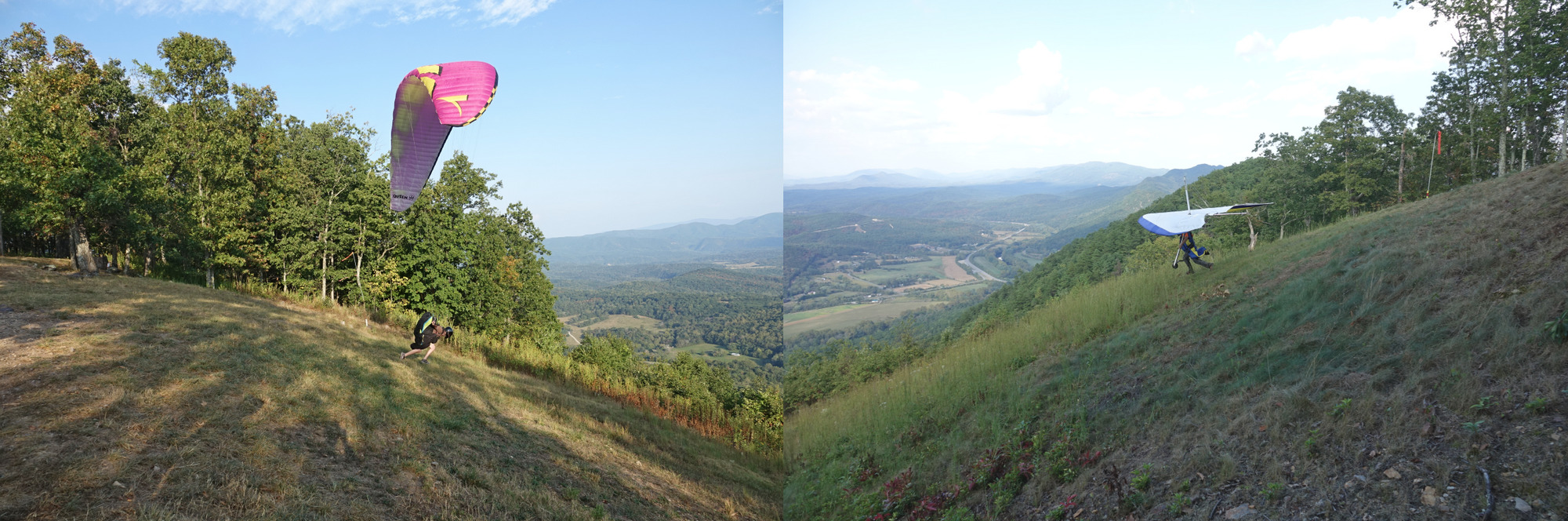
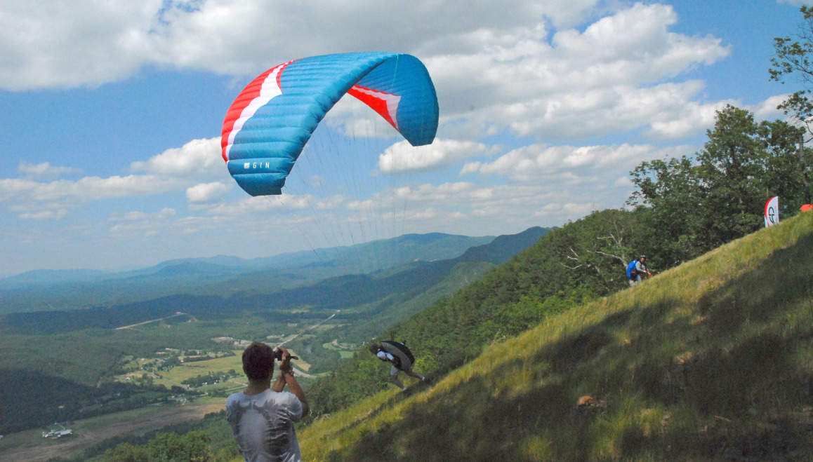
This is the most commonly flown side for a number of reasons. A SE facing site is likely to have upslope convection on most
sunny light wind days. The Main LZ is on the same size of the mountain as the road up, so turn around time is short. For
paraglider pilots the SE Emergency LZ is a popular option, as it can allow a quick test of condition with a very short drive
(or possible walk) back up to try again. The launch is wide and open, and easy for both hang and paraglider pilots. Please see "Weather Conditions" for information about ideal flying conditions.
There is a parking area behind and below the launch slope, which is sheltered from the wind. This is a good location for hang
glider setup in stronger conditions. There is also a small cabin adjacent to launch which is privately owned and often used
by the owners, particularly on weekends. This property should be respected and the owners treated courteously.
NW launch
Launch Faces 325 deg; Overall ridge faces 330 deg
Wind Direction: Ideal 280 to 350 deg, acceptable 270 to 350 deg
Wind Velocity: 0 to 10 mph ideal, 15 mph max, 5 mph gusts max, all pilots
Please park across the gravel road from launch (at the base of the radio tower)
The NW side is flown less often, but can be more rewarding when it is working. The LZ is several hundred feet higher above
the Main LZ than the SE side, but involves substantially longer turn around time/distance, as the LZ is on the opposite side
of the mountain from the access road to launch.
The NW days which favor this side of the mountain are generally associated with cold fronts, which bring clear and unstable
air. This is ideal for extended soaring flights and altitude gains, but can easily increase to unsafe levels, so extra
caution is advised when evaluating the conitions. The launch itself is wide open and steeper than the SE side. Please see
"Weather Conditions" for information about ideal flying conditions.
Parking is somewhat tighter for the NW side, as there is only a small lot across the road from launch, at the base of the
radio tower. However the parking area at the SE launch is in easy walking distance, so equipment can be dropped at the NW
side with parking at the SE site.
Rules
Must be current USHGA member for legal liability and site preservation reasons.
Must have a current H-3/P-3 or higher USHGA rating. H-2/P-2 may fly under the supervision of an Instructor, Observer, or local Site Guide
Helmets must worn.
Always clear traffic and yell, "CLEAR" before taking off and entering the flight pattern.
No use of motors from the launch site.
Dogs must be on a leash when on the launch site and landing field when pilots are preparing to launch, packing up gliders and while launching or landing.
Please post a message on the list with the total number of flights from the mountain that day.
A car going UP the mountain has the right-of-way. Do NOT back down the mountain to let someone pass since this can be dangerous and hard on your brakes.
It is recommended that a pilot fly with someone else
No top landing
No Acro flying at Eagle Rock
BE AWARE
The landing zone just below launch is small and requires accurate landing skills
There are power lines in several of the farmers fields used for landing
Follow the rules of the ridge (see below)
Clear your launches and turns all around, above and below you
After landing, move your glider out of the middle of the field so others can safely land
MISCELLANEOUS
If you have a radio, please USE it. It might save a life (yours!). The official radio frequency is 151.625 MHz. It is strongly encouraged that everyone use a radio.
It may be helpful to carry a cell phone for emergencies.
All vehicles must stay on the roads and park in parking areas.
Do not park on the road or block access to the tower on the top of the mountain.
Do not drive onto or park on the launch site. Park in one of the parking lots.
The site is for day use only. No overnight camping without prior permission from the landowners.
In case of an emergency, ask for a cell phone to call 911.
DO NOT LITTER.
Please respect all landowners property. Remember that we are able to fly only with the consent of the landowners. Please treat all landowners kindly.